Photo Credit: Emily Perkins, SDMMP
Goal: Maintain, enhance and restore oak woodlands on Conserved Lands in the MSPA that support or have the potential to support VF species (i.e., Engelmann Oak, California newt) and coast live oak woodlands that incidentally benefit a diverse array of other MSP species (e.g., Harbison's dun skipper, California newt, pallid bat, mountain lion) so that the vegetation communities have high ecological integrity, and these species are resilient to invasive pests and disease pathogens, environmental stochasticity, threats and catastrophic disturbances, such as very large wildfires and intense and prolonged drought, and will be likely to persist over the long term (>100 years).
Management units: 2, 3, 4, 5, 6, 8, 9, 10, 11
Starting in 2017, map tree mortality in oak woodlands across the MSPA using high resolution aerial imagery, LIDAR and other remote sensing data and incorporate existing datasets, where available, to determine the current status of oak woodlands in the MSPA that are affected by drought, wildfire and invasive pests and fungal pathogens.
| Action | Statement | Action status | Projects |
|---|---|---|---|
| DEV-1 | Submit project metadata, datasets, analyses, and Oak Woodland Tree Mortality Map to the MSP web portal | In progress | 2017-2019 Developing a Map of Ecological Integrity Using Remote Sensing |
| Criteria | Deadline year |
|---|---|
| Oak Woodland Tree Mortality Map completed by 2018 | 2021 |
| Threat Name | Threat Code |
|---|---|
| Altered fire regime | ALTFIR |
| Altered hydrology | ALTHYD |
| Climate change | CLICHN |
| Herbivory/predation | |
| Invasive animals | INVANI |
| Invasive plants | INVPLA |
| Loss of ecological integrity | ECOINT |
| Parasitism/disease | |
| Urban development | URBDEV |
Management units: 2, 3, 4, 5, 6, 8, 9, 10, 11
Beginning in 2019, prepare an oak woodland vegetation monitoring plan for Conserved Lands in the MSPA to assess tree mortality and recruitment, including that of coast live oak and Engelmann oak, track community composition, structure and ecological integrity, and to document threats and assess environmental conditions. Prepare the oak woodland monitoring to integrate where feasible or bulid upon the results of other monitoring projects such as riparian forest and scrub vegetation monitoring, shothole borer/Fusarium complex monitoring, and golden-spotted oak borer and fungal pathogen monitoring. The monitoring plan should include a conceptual model, specific monitoring questions, the sampling frame within the MSPA, monitoring methods, a statistically valid sampling design, permanent sampling locations, timeline, and standardized protocols. Use the Oak Woodland Tree Mortality map and the distribution of coast live oak and Engelmann oaks to develop a sampling frame and stratified sampling design with permanent sampling plots spanning north to south and east to west environmental gradients across the MSPA. Evaluate ecological integrity at monitoring sites by integrating other types of monitoring into the long-term sampling plots, such as abiotic element monitoring (e.g., automated weather stations and soil sensors, GIS-data layers), ecological integrity monitoring (e.g., plant and animal communities, ecological processes), MSP VF species monitoring, and threats monitoring (e.g., fire, climate change, disease, invasive animals and invasive plants).
| Action | Statement | Action status | Projects |
|---|---|---|---|
| PRP-1 | Establish a vegetation monitoring working group of scientists, wildlife agencies, land managers, and other stakeholders to participate in developing the monitoring plan. The group should also include interested parties from outside the MSPA, such as representatives from other multiple species plans in Orange and Riverside Counties and from San Diego County military bases, to create a regional monitoring program with greater efficiencies in effort and a broader inference across southern California. | waiting for precedent action | |
| PRP-2 | Submit project metadata and the Oak Woodland Vegetation Monitoring Plan to the MSP web portal | waiting for precedent action |
| Criteria | Deadline year |
|---|---|
| Oak Woodland Vegetation Monitoring Plan completed by 2020 | 2021 |
| Threat Name | Threat Code |
|---|---|
| Altered fire regime | ALTFIR |
| Altered hydrology | ALTHYD |
| Climate change | CLICHN |
| Herbivory/predation | |
| Invasive animals | INVANI |
| Invasive plants | INVPLA |
| Loss of ecological integrity | ECOINT |
| Parasitism/disease | |
| Urban development | URBDEV |
Management units: 2, 3, 4, 5, 6, 8, 9, 10, 11
In 2021, conduct oak woodland monitoring to implement the Oak Woodland Vegetation Monitoring Plan on Conserved Lands in the MSPA.
| Action | Statement | Action status | Projects |
|---|---|---|---|
| IMP-1 | Submit project metadata, monitoring datasets and reports to the MSP web portal | waiting for precedent action |
| Criteria | Deadline year |
|---|---|
| Oak Woodland Vegetation Monitoring Plan implemented 2021 | 2021 |
| Threat Name | Threat Code |
|---|---|
| Altered fire regime | ALTFIR |
| Altered hydrology | ALTHYD |
| Climate change | CLICHN |
| Herbivory/predation | |
| Invasive animals | INVANI |
| Invasive plants | INVPLA |
| Loss of ecological integrity | ECOINT |
| Parasitism/disease | |
| Urban development | URBDEV |
| Metric | Condition | Trend | Confidence |
|---|---|---|---|
1. Percent ConservedPercent of baseline oak woodlands conserved |
Concern |
Improving |
Moderate |
2. Ecological IntegrityPercent of trees in oak woodlands in high integrity class based on tree greenness |
Good |
Unknown |
Moderate |
|
2017-2019 Developing a Map of Ecological Integrity Using Remote Sensing
This project's objective is to create a map of ecological integrity using remotely sensed data. Data sources include high resolution lidar and high resolution 4-band imagery from multiple sources. Final products from this work will include: 1) an updated high resolution Digital Elevation Model, 2) an updated high resolution Digital Surface Model, 3) a raster image depicting vegetation height (using lidar), 4) a raster image depicting herbaceous, shrub, and tree cover, 5) a map layer of ecological integrity (at a 50m grid) for coastal sage scrub, chaparral, oak woodlands, and riparian woodlands. Ecological integrity is defined for each vegetation community independently, based on analysis of previous field work. This project will build off the information and products previously created.
|
|
Anstine-Audubon Nature Preserve Fencing Project
The goal of this project was to install 855 linear feet of lodge pole fencing along the northern boundary of San Diego Audubon Society’s (SDAS’s) 11.6-acre Anstine-Audubon Nature Preserve (Anstine) in Vista, CA to combat hazardous and non-hazardous dumping and illegal trespassing. The addition of fencing along the northern portion of the property, adjacent to Hidden Lake Lane, will protect the fragile riparian, oak woodland, and endangered coastal sage scrub habitats on the preserve. Urban Corps of San Diego, with SDAS oversight, successfully installed an 855-foot long, five-foot high lodge pole wooden fence along with three access gates on the property in the planned one-year project.
Project Start Date: March 7, 2023
Project Completion Date: January 18, 2024
This project was fully funded by SANDAG TransNet EMP Land Management Grant #S1125499
|
|
Feral Pig Removal Program Monitoring
This is an ongoing project established to support the feral pig removal effort in San Diego County established and funded by land management agencies that have been participating in the Intergovernmental Feral Pig Project. This is an independent monitoring project intended to complement and inform the USDA Wildlife Services-led removal project. The objectives of the project are to monitor feral pigs and their movements through use of telemetry, remote cameras, and collecting field data pre-, during, and post-removal actions to inform efficient and effective removal efforts. The project is also working to coordinate with the Feral Pig Intergovernmental Working Group and provide results of the monitoring efforts on a quarterly basis.
|
|
Harbison's Dun Skipper Surveys and Monitoring
SANDAG-funded surveys for Harbison's dun skipper adults were conducted to assess year to year variation in population size. Field visits were used to document use including plants used for nectar sources, as well as obtain non-lethal genetic samples. A rapid habitat assessment was conducted at each site which included general woodland tree species composition, condition of San Diego sedge plants, and recording potential threats to the Harbison's dun skipper.
|
|
San Dieguito Citizen Science Monitoring Program
The San Dieguito River Valley Conservancy (SDRVC) developed the San Dieguito Citizen Science Monitoring Program as a sustainable, cost-effective, and scientifically valid approach to gather critical data on lands within the San Dieguito River Park Focused Planning Area. This program seeks to fill knowledge gaps on the diversity, population, movements and spatial ecology of species within the watershed to better inform future land acquisitions, adaptive land management, habitat and species restoration, educational initiatives and future research. One of the main objectives of this program is to gather data that is consistent and shared with other regional planning efforts being coordinated by the San Diego Management & Monitoring Program. Data collected is submitted to regional databases and will help meet the management goals and objectives identified in the Management & Monitoring Strategic Plan. Annual expert-led surveys are carried out by volunteer citizen scientists following approved protocols and encourage community involvement and engagement.
|
|
Vegetation Mapping 2026
The goal of this project is to create a new vegetation map for the western portion of San Diego County. This will be based on the Vegetation Classification Manual hierarchical classification system. The map will consist of a group-level comprehensive map based on satellite remote sensing and an alliance/association map focused on existing preserves or important resources.
|
|
Vegetation Mapping and Classification 2012
This project first created a vegetation classification system and manual. Then, based on 2012 data, this project completed 3 tasks: Task 1. Vegetation Mapping. Task 2. Invasive Nonnative Species Plant Mapping. Task 3. Tecate Cypress Mapping. In 2014, the data was updated based on user's comments. The final products are available to download in the data section.
|
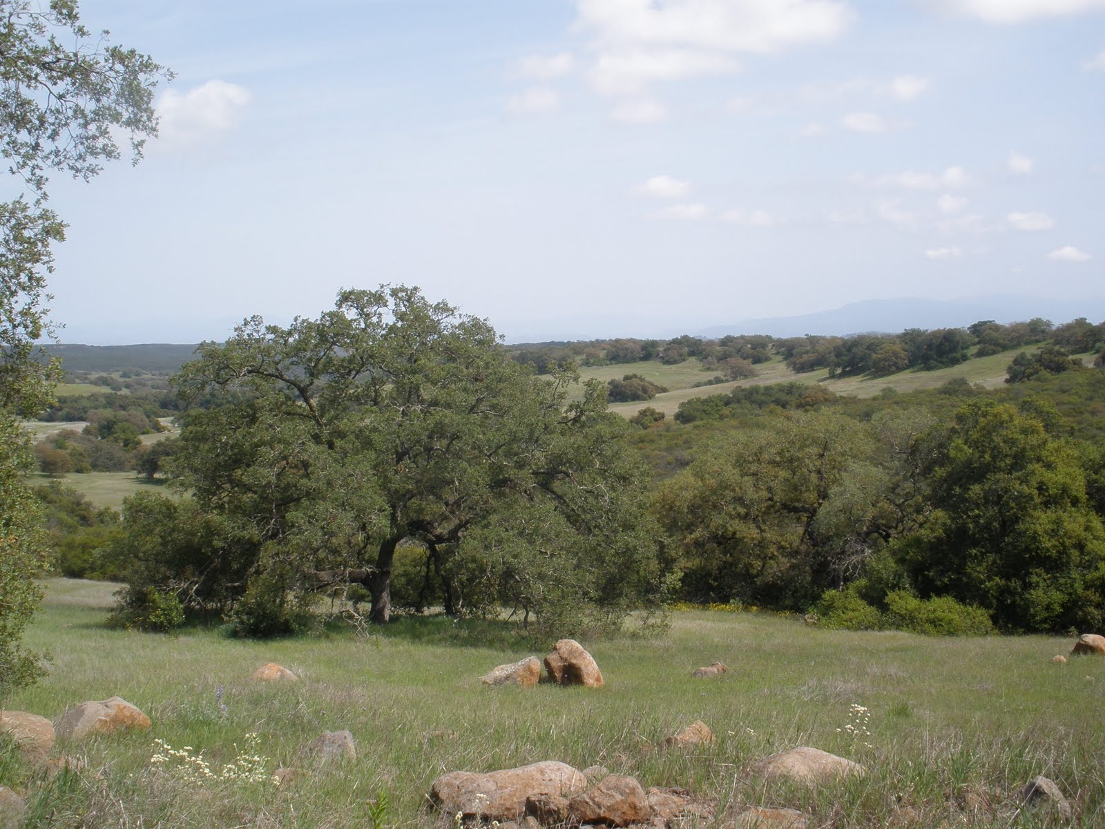
Oak woodland in the MSPA includes primarily coast live oak (Quercus agrifolia) woodland and Engelmann oak (Quercus engelmannii) woodland. In coast live oak woodland, Q. agrifolia trees live for >200-300 years [1]and are generally <30 m tall, the canopy is open to continuous and the shrub layer is poorly developed, but may include Heteromeles arbutifolia, Ribes spp., Malosma laurina, or Sambucus nigra. The herb component is continuous and dominated by Bromus diandrus and several other introduced taxa [2]. In Q. engelmannii woodlands, trees are usually <18 m tall, the canopy is open to closed, the shrub layer is sparse to open and the herbaceous layer is sparse and often dominated by grass species.
The Q. agrifolia alliance includes Q. agrifolia as the dominant or codominant species [1]. Associated tree species include Acer macrophyllum, A. negundo, Arbutus menziesii, Juglans californica, Platanus racemosa, Populus fremontii, Q. douglasii, Q. lobata, Q. engelmannii, Q. kelloggii, Salix lasiolepis, and/or Umbellularia californica. There are four different associations of the alliance: (1) Q. agrifolia/Artemisia californica Association found in drier upland settings adjacent to stands of coastal scrub; (2) Q. agrifolia/Quercus (berberidifolia x acutidens) Association found on lower, mesic slopes adjacent to chaparral stands; (3) Q. agrifolia/Toxicodendron diversilobum/Grass Association is the most widespread association and occurs on lower slopes and terraces, but is not subjected to fluvial processes; and (4) Q. agrifolia/S. lasiolepis Association occurs adjacent to streams. Q. engelmannii is the dominant or codominant in the tree canopy of the Q. engelmannii alliance, with Juglans californica, Q. agrifolia, and Q. kelloggii sometimes present as associates. Stands fall in either the Q.engelmannii/Salvia apiana Association which has a coastal scrub shrub understory, or the more widespread Q. engelmannii-Q.agrifolia/T. diversilobum/Grass Association codominated by Q. agrifolia and Q. engelmannii and a largely herbaceous understory.
Coast live oak woodland occurs along the outer South Coast Ranges, and coastal slopes of Transverse and Peninsular ranges, usually below 1220 m [2]. Intergrades with Blue Oak Woodland in the inner South Coast Ranges and with Engelmann Oak Woodland in interior southern California. Engelmann oak woodland occurs mainly in the foothills of the Peninsular Range in San Diego County and the Santa Ana Mountains of San Diego and Riverside counties below 1220 m [2]. Engelmann oak integrades with coast live oak at higher elevation mesic sites.
There are 78,395 acres of oak woodland in the MSPA in MUs 2,3,4,5,6,8,9,10, and 11, of which, 23,582 acres are conserved [3]. MUs 5, 9, 10 and 11 have the greatest amount of conserved oak woodland in the MSPA.
Coast live oak woodlands are typically found on north-facing slopes and shaded ravines in the south [2]. Coast live oak woodlands may be found in mesic uplands or riparian or semi-riparian settings where fluvial processes affect regeneration [1], whereas Engelmann oak woodland are found on relatively moist sites on fine-textured soils of gentle slopes and valley bottoms.
Fire is the main natural process affecting the upland stands [1]. Fluvial processes may also be present in riparian stands.
Short fire return intervals can eliminate coast live oak stands [1]. Coast live oak are a host species for and threatened by the gold-spotted oak borer and the polyphagous shot hole borer/Fusarium complex [4, 5]. Fire has varied effects on Engelmann oaks where trees with a grassy understory tend to suffer minimal damage, while trees in stands with shrubby understories are top-killed but may survive by resprouting [1]. Engelmann oaks are threatened by agricultural conversions and are not regenerating well [6].
Open Engelmann oak woodlands often occupy the ecotone between the grassland and surrounding shrub fields [2]. Due to minimal regeneration, actively restoring oak or encouraging natural regeneration may be necessary for Engelmann oaks [6]. Oak woodlands support 16 MSP plant and animal species (link to species and vegetation assocation table).
[1] Sproul, F., Keeler-Wolf, T., Gordon-Reedy, P., Dunn, J., Klein, A., & Harper, K. (2011). Vegetation Classification Manual for Western San Diego County (First). San Diego, CA.
[2] Oberbauer, T. A., M. Kelly, and Jeremy Buegge. 2008. Draft Vegetation Communities of San Diego County. Based on “Preliminary Descriptions of the Terrestrial Natural Communities of Californiaâ€, Robert F. Holland, Ph.D., October 1986. San Diego, CA.
[3] Oberbauer, T., F. Sproul, J. Dunn, and L. Wolley. 2012. ECO_VEGETATION_WSD. Prepared by AECOM, California Department of Fish and Wildlife Published by AECOM and SANDAG Technical Services. www.sangis.org. Accessed September 2016.
[4] Coleman, T. W., and S. J. Seybold. 2009. “GSOB ≠SOD : Tree Mortality from the Goldspotted Oak Borer in Oak Woodlands of Southern California 1.†In Sudden Oak Death Fourth Science Symposium, 58–63. Santa Cruz, California.
[5] Eskalen, A. 2013. “New Invasive Beetle / Disease Complex on California Avocado and Landscape Trees : Polyphagous Shot Hole Borer ( Euwallacea Sp .) and Fusarium Dieback ( Fusarium Euwallaceae ).
[6] McCreary, D. D., W. D. Tietje, S. L. Drill, G. A. Giusti, and L. R. Costello. 2011. “Living Among the Oaks: A Management Guide for Woodland Owners and Managers.â€