Vegetation Community in progress

2017-2019 Developing a Map of Ecological Integrity Using Remote Sensing

October 1, 2017
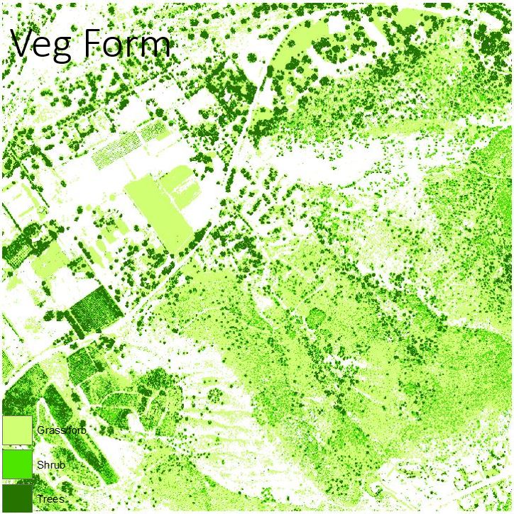
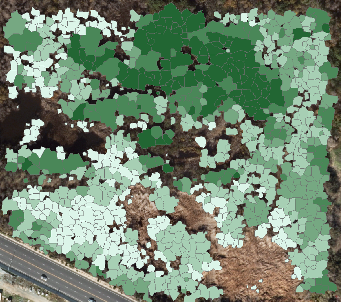
This project's objective is to create a map of ecological integrity using remotely sensed data. Data sources include high resolution lidar and high resolution 4-band imagery from multiple sources. Final products from this work will include: 1) an updated high resolution Digital Elevation Model, 2) an updated high resolution Digital Surface Model, 3) a raster image depicting vegetation height (using lidar), 4) a raster image depicting herbaceous, shrub, and tree cover, 5) a map layer of ecological integrity (at a 50m grid) for coastal sage scrub, chaparral, oak woodlands, and riparian woodlands. Ecological integrity is defined for each vegetation community independently, based on analysis of previous field work. This project will build off the information and products previously created.
Project Groups
  • SDMMP31 Vegetation Monitoring Methods

Project Focus

chaparral, coastal sage scrub, grassland, oak woodland, riparian forest & scrub

San Diego Management and Monitoring Program

Emily Perkins

Emily Perkins

Emily Perkins

Project Protocol

coastal sage scrub

Goal: Maintain, enhance and restore coastal sage scrub on Conserved Lands in the MSPA that supports or has the potential to support VF species (i.e., cliff spurge, Palmer's goldenbush, San Diego barrel cactus, snake cholla, Blaineville's horned lizard, California gnatcatcher, San Diego black-tailed jackrabbit) and to incidentally benefit a diverse array of other species (e.g., San Diego thornmint, Hermes copper, Quino checkerspot, coastal cactus wren) so that the vegetation community has high ecological integrity, and these species are resilient to environmental stochasticity, catastrophic disturbances and threats, such as very large wildfires, invasive plants and prolonged drought, and will be likely to persist over the long term (>100 years).

Regional NFO 2017, 2018, 2019, 2020, 2021
MON-DEV-MAP COSASC-2

Management units: 1, 2, 3, 4, 5, 6, 7, 8, 9, 10, 11

In 2017, develop a landscape-scale map classifying ecological integrity of shrublands across the MSPA based upon shrub cover and density and invasive nonnative annual grasses using remote imagery (e.g., satellite and high resolution aerial imagery, LIDAR) and vegetation data collected during 2015-2016 California gnatcatcher regional and postfire monitoring. Verify and revise the mapping as needed using field data collected in 2018-2020 as part of the Chaparral, Coastal Sage Scrub and Grassland Monitoring Program and from related VF species monitoring (e.g., California gnatcatcher regional and postfire monitoring). Revise the integrity classification map as needed to respond to changes in vegetation based upon wildfires, drought or other large-scale disturbances.

Action Statement Action status Projects
DEV-1 Submit project metadata, datasets, analyses, and Ecological Integrity Classification Map to the MSP web portal In progress 2017-2019 Developing a Map of Ecological Integrity Using Remote Sensing
Criteria Deadline year
Ecological Integrity Map created in 2017 and updated as needed 2018-2021 2021
Threat Name Threat Code
Altered fire regimeALTFIR
Climate changeCLICHN
Invasive plantsINVPLA
Loss of ecological integrityECOINT
Code Obj. code Statement
COSASC-1 MON-PRP-MONPL In 2017, prepare a long-term monitoring plan for the mosaic of chaparral, coastal sage scrub and grassland vegetation communities that focuses on tracking community composition, structure and ecological integrity over time in relation to climate (i.e., drought) and disturbance from fire. The monitoring plan should include a conceptual model, specific monitoring questions, the sampling frame within the MSPA, monitoring methods, a statistically valid sampling design, permanent sampling locations, timeline, and standardized protocols. Use the landscape-scale ecological integrity classification map to develop a sampling frame and the sampling design with permanent sampling plots spanning north to south and east to west environmental gradients across the MSPA. Evaluate how the vegetation integrity classes characterize other aspects of the ecosystem by integrating other types of monitoring into the long-term sampling plots, such as abiotic element monitoring (e.g., automated weather stations and soil sensors, GIS-data layers), ecological integrity monitoring (e.g., plant and animal communities, ecological processes), MSP VF species monitoring, and threats monitoring (e.g., fire, climate change, invasive plants). A draft monitoring plan should be prepared in 2017, tested in the field with a pilot study in 2018, and finalized by 2019.
COSASC-3 MON-IMP-MONPL In 2018, conduct pilot monitoring to collect data and develop any recommendations for finalizing the monitoring plan. From 2019 to 2021, implement the final Chaparral, Coastal Sage Scrub and Grassland Vegetation Monitoring Plan.
POLPOL-1 MON-IMP-MONPL In 2020, implement regional and subregional California gnatcatcher monitoring initiated in 2016 to determine the percent area occupied (PAO) by California gnatcatcher in modeled high and very high suitability habitat on Conserved Lands and military lands in the MSPA as part of a larger monitoring program for southern California. Over the next 15 years, determine trends in California gnatcatcher PAO and in their colonization and extinction rates and be able to detect at least 30% change in PAO. Identify associations between habitat and threat correlates with gnatcatcher PAO and with extinction and colonization rates and develop biologically meaningful thresholds for management and to specify management criteria and recommendations.
POLPOL-2 MON-RES-SPEC In 2020, implement California gnatcatcher postfire monitoring conducted in 2015 and 2015 to: determine whether there has been further recovery of California gnatcatchers in areas burned in 2003, 2007 and 2014 (i.e., PAO>10%); evaluate if there is a difference in PAO between areas burned in 2003, 2007 and 2014; investigate the relationship between gnatcatcher PAO and vegetation composition, cover and structure; and evaluate the composition, cover and structure of coastal sage scrub in areas with different fire frequencies and patterns of vegetation recovery based upon time since fire, spatial distribution, previous land use, and environmental conditions. Use the regional gnatcatcher and vegetation monitoring protocols to monitor postfire recovery of gnatcatchers and vegetation at sampling points surveyed in 2016. Analyze gnatcatcher and vegetation data to develop overall and site specific vegetation management recommendations for postfire recovery of coastal sage scrub vegetation to support California gnatcatchers.

chaparral

Goal: Maintain, enhance and restore chaparral on Conserved Lands in the MSPA that supports or has the potential to support VF species (i.e., Del Mar manzanita, felt-leaved monardella, Lakeside ceanothus, Nuttall's scrub oak, Otay manzanita, Rainbow manzanita, wart-stemmed ceanothus, California newt, Bell's sage sparrow) and to incidentally benefit a diverse array of other species (e.g., Encinitas baccharis, Jennifer's monardella, Orcutt's hazardia, mountain lion) so that the vegetation community has high ecological integrity, and these species are resilient to environmental stochasticity, catastrophic disturbances and threats, such as very large wildfires and prolonged droughts, and will be likely to persist over the long term (>100 years).

Regional NFO 2017, 2018, 2019, 2020, 2021
MON-DEV-MAP CHAPAR-2

Management units: 1, 2, 3, 4, 5, 6, 7, 8, 9, 10, 11

In 2017, develop a landscape-scale map classifying ecological integrity of shrublands across the MSPA based upon shrub cover and density and invasive nonnative annual grasses using remote imagery (e.g., satellite and high resolution aerial imagery, LIDAR) and vegetation data collected during 2015-2016 California gnatcatcher regional and postfire monitoring. Verify and revise the mapping as needed using field data collected in 2018-2020 as part of the Chaparral, Coastal Sage Scrub and Grassland Vegetation Monitoring Program and from related VF species monitoring (e.g., California gnatcatcher regional and postfire monitoring). Revise the integrity classification map as needed to respond to changes in vegetation based upon wildfires, drought or other large-scale disturbances.

Action Statement Action status Projects
DEV-1 Submit project metadata, datasets, analyses, and Ecological Integrity Classification Map to the MSP web portal In progress 2017-2019 Developing a Map of Ecological Integrity Using Remote Sensing
Criteria Deadline year
Ecological Integrity Map created in 2017 and updated as needed 2018-2021 2021
Threat Name Threat Code
Altered fire regimeALTFIR
Climate changeCLICHN
Invasive plantsINVPLA
Loss of ecological integrityECOINT
Code Obj. code Statement
CHAPAR-1 MON-PRP-MONPL In 2017, prepare a long-term monitoring plan for the mosaic of chaparral, coastal sage scrub and grassland vegetation communities that focuses on tracking community composition, structure and ecological integrity over time in relation to climate (i.e., drought) and disturbance from fire. The monitoring plan should include a conceptual model, specific monitoring questions, the sampling frame within the MSPA, monitoring methods, a statistically valid sampling design, permanent sampling locations, timeline, and standardized protocols. Use the landscape-scale ecological integrity classification map to develop a sampling frame and the sampling design with permanent sampling plots spanning north to south and east to west environmental gradients across the MSPA. Evaluate how the vegetation integrity classes characterize other aspects of the ecosystem by integrating other types of monitoring into the long-term sampling plots, such as abiotic element monitoring (e.g., automated weather stations and soil sensors, GIS-data layers), ecological integrity monitoring (e.g., plant and animal communities, ecological processes), MSP VF species monitoring, and threats monitoring (e.g., fire, climate change, invasive plants). A draft monitoring plan should be prepared in 2017, tested in the field with a pilot study in 2018, and finalized by 2019.
CHAPAR-3 MON-IMP-MONPL In 2018, conduct pilot monitoring to collect data and develop any recommendations for finalizing the vegetation monitoring plan. In 2019 to 2021, implement the final Chaparral, Coastal Sage Scrub and Grassland Vegetation Monitoring Plan.
POLPOL-1 MON-IMP-MONPL In 2020, implement regional and subregional California gnatcatcher monitoring initiated in 2016 to determine the percent area occupied (PAO) by California gnatcatcher in modeled high and very high suitability habitat on Conserved Lands and military lands in the MSPA as part of a larger monitoring program for southern California. Over the next 15 years, determine trends in California gnatcatcher PAO and in their colonization and extinction rates and be able to detect at least 30% change in PAO. Identify associations between habitat and threat correlates with gnatcatcher PAO and with extinction and colonization rates and develop biologically meaningful thresholds for management and to specify management criteria and recommendations.
POLPOL-2 MON-RES-SPEC In 2020, implement California gnatcatcher postfire monitoring conducted in 2015 and 2015 to: determine whether there has been further recovery of California gnatcatchers in areas burned in 2003, 2007 and 2014 (i.e., PAO>10%); evaluate if there is a difference in PAO between areas burned in 2003, 2007 and 2014; investigate the relationship between gnatcatcher PAO and vegetation composition, cover and structure; and evaluate the composition, cover and structure of coastal sage scrub in areas with different fire frequencies and patterns of vegetation recovery based upon time since fire, spatial distribution, previous land use, and environmental conditions. Use the regional gnatcatcher and vegetation monitoring protocols to monitor postfire recovery of gnatcatchers and vegetation at sampling points surveyed in 2016. Analyze gnatcatcher and vegetation data to develop overall and site specific vegetation management recommendations for postfire recovery of coastal sage scrub vegetation to support California gnatcatchers.

oak woodland

Goal: Maintain, enhance and restore oak woodlands on Conserved Lands in the MSPA that support or have the potential to support VF species (i.e., Engelmann Oak, California newt) and coast live oak woodlands that incidentally benefit a diverse array of other MSP species (e.g., Harbison's dun skipper, California newt, pallid bat, mountain lion) so that the vegetation communities have high ecological integrity, and these species are resilient to invasive pests and disease pathogens, environmental stochasticity, threats and catastrophic disturbances, such as very large wildfires and intense and prolonged drought, and will be likely to persist over the long term (>100 years).

Regional NFO 2017, 2018
MON-DEV-MAP OAKWOO-1

Management units: 2, 3, 4, 5, 6, 8, 9, 10, 11

Starting in 2017, map tree mortality in oak woodlands across the MSPA using high resolution aerial imagery, LIDAR and other remote sensing data and incorporate existing datasets, where available, to determine the current status of oak woodlands in the MSPA that are affected by drought, wildfire and invasive pests and fungal pathogens.

Action Statement Action status Projects
DEV-1 Submit project metadata, datasets, analyses, and Oak Woodland Tree Mortality Map to the MSP web portal In progress 2017-2019 Developing a Map of Ecological Integrity Using Remote Sensing
Criteria Deadline year
Oak Woodland Tree Mortality Map completed by 2018 2021
Code Obj. code Statement
OAKWOO-2 MON-PRP-MONPL Beginning in 2019, prepare an oak woodland vegetation monitoring plan for Conserved Lands in the MSPA to assess tree mortality and recruitment, including that of coast live oak and Engelmann oak, track community composition, structure and ecological integrity, and to document threats and assess environmental conditions. Prepare the oak woodland monitoring to integrate where feasible or bulid upon the results of other monitoring projects such as riparian forest and scrub vegetation monitoring, shothole borer/Fusarium complex monitoring, and golden-spotted oak borer and fungal pathogen monitoring. The monitoring plan should include a conceptual model, specific monitoring questions, the sampling frame within the MSPA, monitoring methods, a statistically valid sampling design, permanent sampling locations, timeline, and standardized protocols. Use the Oak Woodland Tree Mortality map and the distribution of coast live oak and Engelmann oaks to develop a sampling frame and stratified sampling design with permanent sampling plots spanning north to south and east to west environmental gradients across the MSPA. Evaluate ecological integrity at monitoring sites by integrating other types of monitoring into the long-term sampling plots, such as abiotic element monitoring (e.g., automated weather stations and soil sensors, GIS-data layers), ecological integrity monitoring (e.g., plant and animal communities, ecological processes), MSP VF species monitoring, and threats monitoring (e.g., fire, climate change, disease, invasive animals and invasive plants).
QUEENG-1 MON-IMP-MONPL In 2021, conduct Engelmann oak woodland monitoring as part of implementation of the Oak Woodland Vegetation Monitoring Plan on Conserved Lands in the MSPA.

grassland

Goal: Enhance and restore native grasslands and forblands and manage nonnative grasslands on Conserved Lands in the MSPA that support or have the potential to support VF species (i.e., grasshopper sparrow and San Diego black-tailed jackrabbit) and to incidentally benefit a diverse array of other species (e.g., Quino checkerspot, burrowing owl, golden eagle, Stephen's kangaroo rat) so that the vegetation communities have high ecological integrity, and these species are resilient to environmental stochasticity and will be likely to persist over the long term (>100 years).

Regional NFO 2017, 2018, 2019, 2020, 2021
MON-DEV-MAP GRASSL-2

Management units: 1, 2, 3, 4, 5, 6, 7, 8, 9, 10, 11

In 2017, develop a landscape-scale map classifying ecological integrity of shrublands across the MSPA based upon shrub cover and density and invasive nonnative annual grasses using remote imagery (e.g., satellite and high resolution aerial imagery, LIDAR) and vegetation data collected during 2015-2016 California gnatcatcher regional and postfire monitoring. Verify and revise the mapping as needed using field data collected in 2018-2020 as part of the Chaparral, Coastal Sage Scrub and Grassland Monitoring Program and from related VF species monitoring (e.g., California gnatcatcher regional and postfire monitoring). Revise the integrity classification map as needed to respond to changes in vegetation based upon wildfires, drought or other large-scale disturbances.

Action Statement Action status Projects
DEV-1 Submit project metadata, datasets, analyses, and Ecological Integrity Classification Map to the MSP web portal In progress 2017-2019 Developing a Map of Ecological Integrity Using Remote Sensing
Criteria Deadline year
Ecological Integrity Map created in 2017 and updated as needed 2018-2021 2021
Threat Name Threat Code
Altered fire regimeALTFIR
Climate changeCLICHN
Invasive plantsINVPLA
Loss of ecological integrityECOINT
Code Obj. code Statement
COSASC-1 MON-PRP-MONPL In 2017, prepare a long-term monitoring plan for the mosaic of chaparral, coastal sage scrub and grassland vegetation communities that focuses on tracking community composition, structure and ecological integrity over time in relation to climate (i.e., drought) and disturbance from fire. The monitoring plan should include a conceptual model, specific monitoring questions, the sampling frame within the MSPA, monitoring methods, a statistically valid sampling design, permanent sampling locations, timeline, and standardized protocols. Use the landscape-scale ecological integrity classification map to develop a sampling frame and the sampling design with permanent sampling plots spanning north to south and east to west environmental gradients across the MSPA. Evaluate how the vegetation integrity classes characterize other aspects of the ecosystem by integrating other types of monitoring into the long-term sampling plots, such as abiotic element monitoring (e.g., automated weather stations and soil sensors, GIS-data layers), ecological integrity monitoring (e.g., plant and animal communities, ecological processes), MSP VF species monitoring, and threats monitoring (e.g., fire, climate change, invasive plants). A draft monitoring plan should be prepared in 2017, tested in the field with a pilot study in 2018, and finalized by 2019.
COSASC-3 MON-IMP-MONPL In 2018, conduct pilot monitoring to collect data and develop any recommendations for finalizing the monitoring plan. From 2019 to 2021, implement the final Chaparral, Coastal Sage Scrub and Grassland Vegetation Monitoring Plan.
POLPOL-1 MON-IMP-MONPL In 2020, implement regional and subregional California gnatcatcher monitoring initiated in 2016 to determine the percent area occupied (PAO) by California gnatcatcher in modeled high and very high suitability habitat on Conserved Lands and military lands in the MSPA as part of a larger monitoring program for southern California. Over the next 15 years, determine trends in California gnatcatcher PAO and in their colonization and extinction rates and be able to detect at least 30% change in PAO. Identify associations between habitat and threat correlates with gnatcatcher PAO and with extinction and colonization rates and develop biologically meaningful thresholds for management and to specify management criteria and recommendations.
POLPOL-2 MON-RES-SPEC In 2020, implement California gnatcatcher postfire monitoring conducted in 2015 and 2015 to: determine whether there has been further recovery of California gnatcatchers in areas burned in 2003, 2007 and 2014 (i.e., PAO>10%); evaluate if there is a difference in PAO between areas burned in 2003, 2007 and 2014; investigate the relationship between gnatcatcher PAO and vegetation composition, cover and structure; and evaluate the composition, cover and structure of coastal sage scrub in areas with different fire frequencies and patterns of vegetation recovery based upon time since fire, spatial distribution, previous land use, and environmental conditions. Use the regional gnatcatcher and vegetation monitoring protocols to monitor postfire recovery of gnatcatchers and vegetation at sampling points surveyed in 2016. Analyze gnatcatcher and vegetation data to develop overall and site specific vegetation management recommendations for postfire recovery of coastal sage scrub vegetation to support California gnatcatchers.

riparian forest & scrub

Goal: Maintain, enhance and restore riparian forest and scrub on Conserved Lands in the MSPA that supports or has the potential to support VF species (i.e., California newt, yellow-breasted chat) and to incidentally benefit a diverse array of other species (e.g., arroyo toad, southwestern pond turtle, least Bell's vireo, southwestern willow flycatcher, Townsend's big-eared bat) so that the vegetation community has high ecological integrity, and these species are resilient to invasive pests and disease pathogens, environmental stochasticity, threats and catastrophic disturbances, such as very large wildfires and intense and prolonged drought, and will be likely to persist over the long term (>100 years).

Regional NFO 2017, 2018
MON-DEV-MAP RIPFOR-1

Management units: 1, 2, 3, 4, 5, 6, 7, 8, 9, 10, 11

In 2017-2018, map tree mortality in riparian forests across the MSPA using high resolution aerial imagery, LIDAR and other remote sensing data and incorporate existing datasets, where available, to determine the current status of riparian forest and scrub in the MSPA that are affected by drought, wildfire and invasive pests and fungal pathogens.

Action Statement Action status Projects
DEV-1 Submit project metadata, datasets, analyses, and Riparian Forest Tree Mortality Map to the MSP web portal In progress 2017-2019 Developing a Map of Ecological Integrity Using Remote Sensing
Criteria Deadline year
Riparian Forest and Scrub Mortality Map completed by 2018 2021
Code Obj. code Statement
RIPFOR-2 MON-PRP-MONPL Beginning in 2019, prepare a riparian forest and scrub vegetation monitoring plan for Conserved Lands in the MSPA to assess tree mortality and recruitment, track community composition, structure and ecological integrity, and to document threats and assess environmental conditions. Prepare the riparian forest and scrub monitoring to integrate where feasible or bulid upon the results of other monitoring projects such as oak woodland vegetation monitoring and shothole borer/Fusarium complex monitoring. The monitoring plan should include a conceptual model, specific monitoring questions, the sampling frame within the MSPA, monitoring methods, a statistically valid sampling design, permanent sampling locations, timeline, and standardized protocols. Use the Riparian Forest and Scrub Tree Mortality map to help develop a sampling frame and stratified sampling design with permanent sampling plots spanning north to south and east to west environmental gradients across the MSPA. Evaluate ecological integrity at monitoring sites by integrating other types of monitoring into the long-term sampling plots, such as abiotic element monitoring (e.g., automated weather stations and soil sensors, GIS-data layers), ecological integrity monitoring (e.g., plant and animal communities, ecological processes), MSP VF species monitoring, and threats monitoring (e.g., fire, climate change, disease, invasive animals and invasive plants).